Docklands Light Railway Map – DLR Line
Updated: January 2025
Welcome to the Docklands Light Railway (DLR) line map website.
DLR Line maps
Below is the map showing the stations.
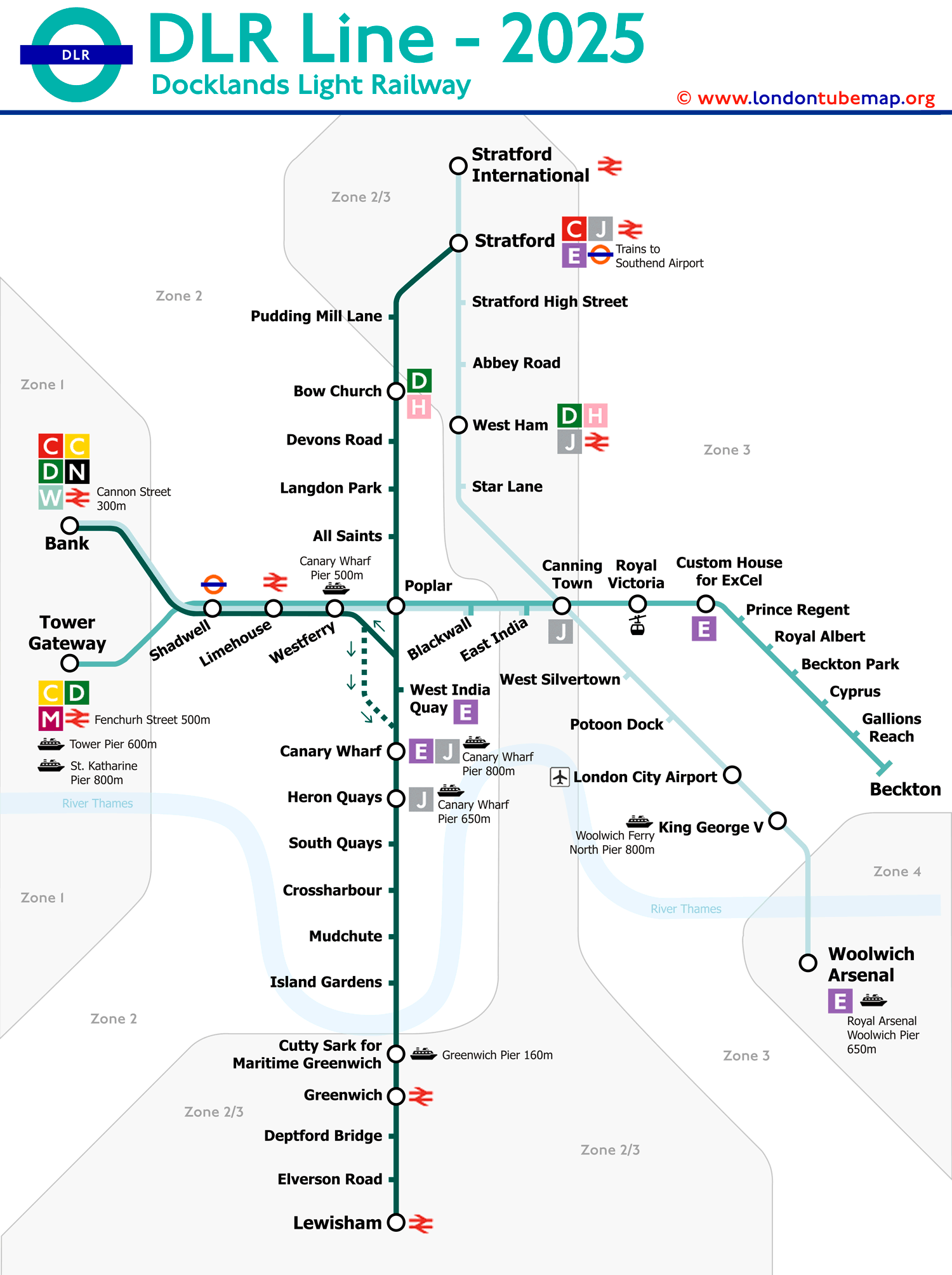
The Docklands Light Railway (DLR) serves the east of the city of London, and although it's a 'light rail' and not a tube, since it's not entirely underground and its tracks do not directly connect with other tube lines, they use the same tickets and appear on tube maps anyway.
A curiosity about this line is that the trains are driverless, but there is always a 'passenger service agent' (PSA) who ensures that everything runs smoothly, and who can take control of the train in an emergency.
Construction of this line began in 1980 as a way of regenerating the East London docks, which had been in decline since the 1960s. Initially, it was meant to be a tramway, but the plans evolved due to a significant increase in passenger numbers, and gradually new stations and sub-lines were added, making the line map a bit more complicated.
Although it looks like a spider web of routes on the map, it actually covers these four routes:
- Bank to Lewisham.
- Tower Gateway to Beckton.
- Stratford to Lewisham.
- Bank to King George V.
The Docklands Light Railway (DLR) is one of the most heavily used lines in the London tube network. In 2013, it averaged 101 million passengers annually. However, by the financial year 2022/23, passenger numbers on the DLR had reached 92.3 million, reflecting ongoing high usage and the dynamic nature of public transportation in London.
List of DLR line stations and routes
The DLR currently operates 5 different routes. Before boarding, ensure to carefully check the destination sign at the front of the train to avoid boarding the wrong service.
Clicking on a station name provides real-time timetable information and additional details. Clicking on the line icons reveals information about that line, including transfer options.
Route 1: Bank - Lewisham
| STATIONS | ZONE | INFO |
|---|---|---|
| Bank | 1 | |
| Shadwell | 2 | |
| Limehouse | 2 | |
| Westferry | 2 | |
| Canary Wharf | 2 | |
| Heron Quays | 2 | |
| South Quay | 2 | |
| Crossharbour | 2 | |
| Mudchute | 2 | |
| Island Gardens | 2 | |
| Cutty Sark (for Maritime Greenwich) | 2/3 | |
| Greenwich | 2/3 | |
| Deptford Bridge | 2/3 | |
| Elverson Road | 2/3 | |
| Lewisham | 2/3 |
Route 2: Bank - Woolwich Arsenal
| STATIONS | ZONE | INFO |
|---|---|---|
| Bank | 1 | |
| Shadwell | 2 | |
| Limehouse | 2 | |
| Westferry | 2 | |
| Poplar | 2 | |
| Blackwall | 2 | |
| East India | 2 | |
| Canning Town | 2/3 | |
| West Silvertown | 3 | |
| Pontoon Dock | 3 | |
| London City Airport | 3 | |
| King George V | 3 | |
| Woolwich Arsenal | 4 |
Route 3: Stratford - Canary Wharf
| STATIONS | ZONE | INFO |
|---|---|---|
| Stratford | 2/3 | |
| Pudding Mill Lane | 2/3 | |
| Bow Church | 2 | |
| Devons Road | 2 | |
| Langdon Park | 2 | |
| All Saints | 2 | |
| Poplar | 2 | |
| West India Quay | 2 | |
| Canary Wharf | 2 |
Route 4: Statford International - Woolwich
| STATIONS | ZONE | INFO |
|---|---|---|
| Stratford International | 2/3 | |
| Stratford | 2/3 | |
| Stratford High Street | 2/3 | |
| Abbey Road | 2/3 | |
| West Ham | 2/3 | |
| Star Lane | 2/3 | |
| Canning Town | 2/3 | |
| West Silvertown | 3 | |
| Pontoon Dock | 3 | |
| London City Airport | 3 | |
| King George V | 3 | |
| Woolwich Arsenal | 4 |
Route 5: Tower Gateway - Beckton
| STATIONS | ZONE | INFO |
|---|---|---|
| Tower Gateway | 1 | |
| Shadwell | 2 | |
| Limehouse | 2 | |
| Westferry | 2 | |
| Poplar | 2 | |
| Blackwall | 2 | |
| East India | 2/3 | |
| Canning Town | 2/3 | |
| Royal Victoria | 3 | |
| Custom House (for ExCel) | 3 | |
| Prince Regent | 3 | |
| Royal Albert | 3 | |
| Beckton Park | 3 | |
| Cyprus | 3 | |
| Gallions Reach | 3 | |
| Beckton | 3 |
London tube map | Timetable | Fares | All tube lines