Karte der Docklands Light Railway (DLR-Linie)
Aktualisiert: Januar 2025
Willkommen auf der Webseite der Docklands Light Railway (DLR)-Linie.
Karten der DLR-Linie
Unten ist die Karte mit den Stationen dargestellt.
→ Vergrößern ←
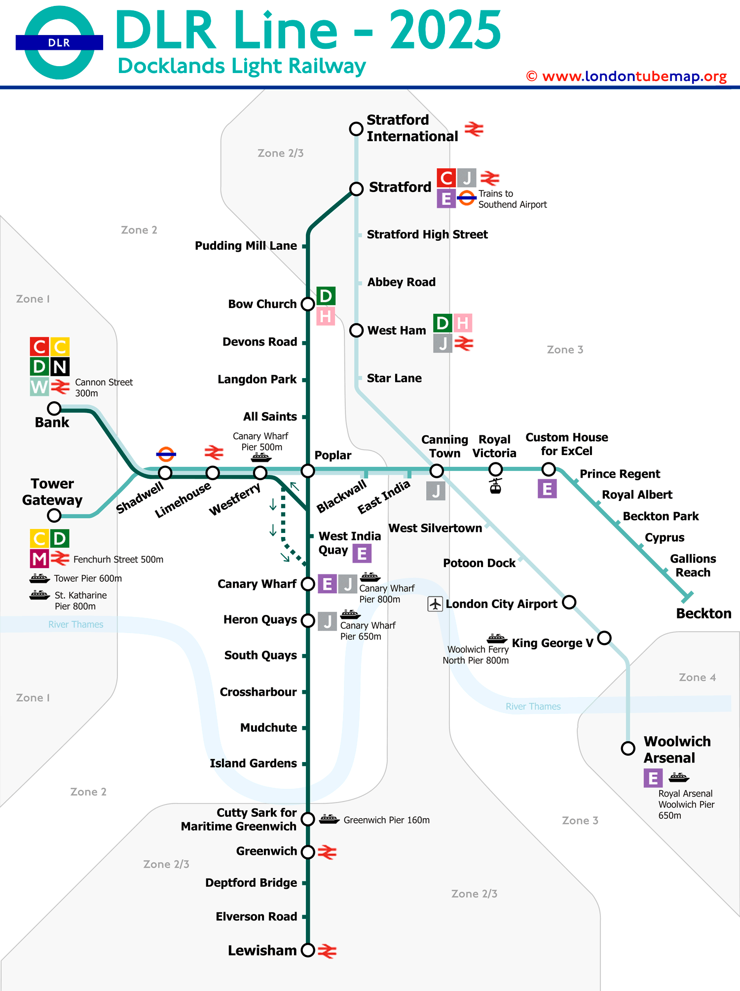
Die Docklands Light Railway (DLR) bedient den Osten der Stadt London, und obwohl es sich um eine 'leichte Bahn' und nicht um eine U-Bahn handelt, da sie nicht vollständig unterirdisch ist und ihre Gleise sich nicht direkt mit anderen U-Bahn-Linien verbinden, verwenden sie dennoch die gleichen Fahrkarten und erscheinen auf U-Bahn-Karten.
Eine Besonderheit dieser Linie ist, dass die Züge fahrerlos sind, es aber immer einen 'Passenger Service Agent' (PSA) gibt, der dafür sorgt, dass alles reibungslos läuft und der im Notfall die Kontrolle über den Zug übernehmen kann.
Der Bau dieser Linie begann 1980 als Mittel zur Regeneration der Ostlondoner Docks, die seit den 1960er Jahren im Niedergang waren. Ursprünglich sollte es eine Straßenbahn werden, aber die Pläne entwickelten sich aufgrund eines signifikanten Anstiegs der Passagierzahlen weiter, und allmählich wurden neue Stationen und Nebenlinien hinzugefügt, was die Linienkarte etwas komplizierter machte.
Obwohl sie auf der Karte wie ein Spinnennetz von Routen aussieht, deckt sie tatsächlich diese vier Routen ab:
- Bank nach Lewisham.
- Tower Gateway nach Beckton.
- Stratford nach Lewisham.
- Bank nach King George V.
Die Docklands Light Railway (DLR) ist eine der am stärksten genutzten Linien im Londoner U-Bahn-Netz. Im Jahr 2013 hatte sie durchschnittlich 101 Millionen Passagiere jährlich. Jedoch erreichten die Passagierzahlen auf der DLR im Finanzjahr 2022/23 92,3 Millionen, was die anhaltend hohe Nutzung und die dynamische Natur des öffentlichen Verkehrs in London widerspiegelt.
Liste der DLR-Linienstationen und -routen
Die DLR betreibt derzeit 5 verschiedene Routen. Vor dem Einsteigen stellen Sie sicher, das Zielzeichen an der Front des Zuges sorgfältig zu überprüfen, um nicht den falschen Dienst zu besteigen.
Ein Klick auf einen Stationsnamen liefert Echtzeit-Fahrplaninformationen und zusätzliche Details. Ein Klick auf die Linienicons offenbart Informationen über diese Linie, einschließlich Umsteigemöglichkeiten.
Route 1: Bank - Lewisham
| STATIONEN | ZONE | INFO | Bank | 1 |
|---|---|---|
| Shadwell | 2 | |
| Limehouse | 2 | |
| Westferry | 2 | |
| Canary Wharf | 2 | |
| Heron Quays | 2 | |
| South Quay | 2 | |
| Crossharbour | 2 | |
| Mudchute | 2 | |
| Island Gardens | 2 | |
| Cutty Sark (for Maritime Greenwich) | 2/3 | |
| Greenwich | 2/3 | |
| Deptford Bridge | 2/3 | |
| Elverson Road | 2/3 | |
| Lewisham | 2/3 |
Route 2: Bank - Woolwich Arsenal
| STATIONEN | ZONE | INFO | Bank | 1 |
|---|---|---|
| Shadwell | 2 | |
| Limehouse | 2 | |
| Westferry | 2 | |
| Poplar | 2 | |
| Blackwall | 2 | |
| East India | 2 | |
| Canning Town | 2/3 | |
| West Silvertown | 3 | |
| Pontoon Dock | 3 | |
| London City Airport | 3 | |
| King George V | 3 | |
| Woolwich Arsenal | 4 |
Route 3: Stratford - Canary Wharf
| STATIONEN | ZONE | INFO | Stratford | 2/3 |
|---|---|---|
| Pudding Mill Lane | 2/3 | |
| Bow Church | 2 | |
| Devons Road | 2 | |
| Langdon Park | 2 | |
| All Saints | 2 | |
| Poplar | 2 | |
| West India Quay | 2 | |
| Canary Wharf | 2 |
Route 4: Statford International - Woolwich
| STATIONEN | ZONE | INFO | Stratford International | 2/3 |
|---|---|---|
| Stratford | 2/3 | |
| Stratford High Street | 2/3 | |
| Abbey Road | 2/3 | |
| West Ham | 2/3 | |
| Star Lane | 2/3 | |
| Canning Town | 2/3 | |
| West Silvertown | 3 | |
| Pontoon Dock | 3 | |
| London City Airport | 3 | |
| King George V | 3 | |
| Woolwich Arsenal | 4 |
Route 5: Tower Gateway - Beckton
| STATIONEN | ZONE | INFO | Tower Gateway | 1 |
|---|---|---|
| Shadwell | 2 | |
| Limehouse | 2 | |
| Westferry | 2 | |
| Poplar | 2 | |
| Blackwall | 2 | |
| East India | 2/3 | |
| Canning Town | 2/3 | |
| Royal Victoria | 3 | |
| Custom House (for ExCel) | 3 | |
| Prince Regent | 3 | |
| Royal Albert | 3 | |
| Beckton Park | 3 | |
| Cyprus | 3 | |
| Gallions Reach | 3 | |
| Beckton | 3 |
Wenn Sie möchten, können Sie den gesamten Londoner U-Bahn-Plan einsehen, eine Seite mit allen Linien zusammengefasst, oder Sie können jede Linie separat betrachten.
Londoner U-Bahn-Karte | Fahrplan | Tarife | Alle U-Bahn-Linien