Plan des lignes de tramway
Mis à jour : Avril 2024
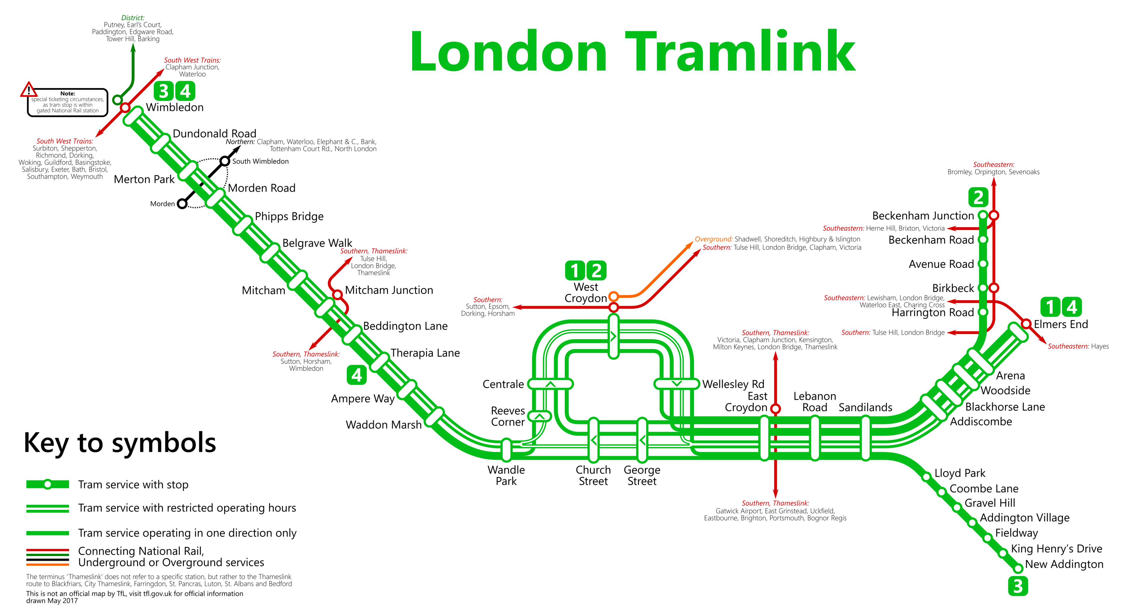
Bienvenue sur le site des plans des lignes de tramway de Londres. Consultez les stations sur la carte ci-dessous (Avril 2024).
 De Metrophil - Auteur, CC BY-SA 4.0.
Si vous souhaitez explorer l'intégralité du réseau du métro de Londres, vous êtes invité à consulter le plan complet du métro de Londres. Cette ressource comprend une page où toutes les lignes sont présentées ensemble de manière ordonnée Plan du métro de Londres (tout en étant clairement séparées), ou vous pouvez choisir d'examiner les lignes individuellement.
Liste des stations et itinéraires du tramway de Londres
Itinéraire 1: Beckenham Junction - Wimbledon
| STATIONS | ZONE | INFOS |
|---|---|---|
| Beckenham Junction | --- | |
| Beckenham Road | --- | |
| Avenue Road | --- | |
| Birkbeck | --- | |
| Harrington Road | --- | |
| Arena | --- | |
| Woodside | --- | |
| Blackhorse Lane | --- | |
| Addiscombe | --- | |
| Sandilands | --- | |
| Lebanon Road | --- | |
| East Croydon | --- | |
| George Street | --- | |
| Church Street | --- | |
| Wandle Park | --- | |
| Waddon Marsh | --- | |
| Ampere Way | --- | |
| Therapia Lane | --- | |
| Beddington Lane | --- | |
| Mitcham Junction | --- | |
| Mitcham | --- | |
| Belgrave Walk | --- | |
| Phipps Bridge | --- | |
| Morden Road | --- | |
| Merton Park | --- | |
| Dundonald Road | --- | |
| Wimbledon | --- |
Itinéraire 2: Elmers End - Wimbledon
| STATIONS | ZONE | INFOS |
|---|---|---|
| Elmers End | --- | |
| Arena | --- | |
| Woodside | --- | |
| Blackhorse Lane | --- | |
| Addiscombe | --- | |
| Sandilands | --- | |
| Lebanon Road | --- | |
| East Croydon | --- | |
| George Street | --- | |
| Church Street | --- | |
| Wandle Park | --- | |
| Waddon Marsh | --- | |
| Ampere Way | --- | |
| Therapia Lane | --- | |
| Beddington Lane | --- | |
| Mitcham Junction | --- | |
| Mitcham | --- | |
| Belgrave Walk | --- | |
| Phipps Bridge | --- | |
| Morden Road | --- | |
| Merton Park | --- | |
| Dundonald Road | --- | |
| Wimbledon | --- |
Itinéraire 3: New Addington - Church Street
| STATIONS | ZONE | INFOS |
|---|---|---|
| New Addington | --- | |
| King Henry's Drive | --- | |
| Fieldway | --- | |
| Addington Village | --- | |
| Gravel Hill | --- | |
| Coombe Lane | --- | |
| Lloyd Park | --- | |
| Sandilands | --- | |
| Lebanon Road | --- | |
| East Croydon | --- | |
| George Street | --- | |
| Church Street | --- |
Plan du métro de Londres | Horaires | Tarifs | Toutes les lignes de métro | Plan métro Paris