Mapa de las Líneas de Tranvía
Actualizado: Enero 2025
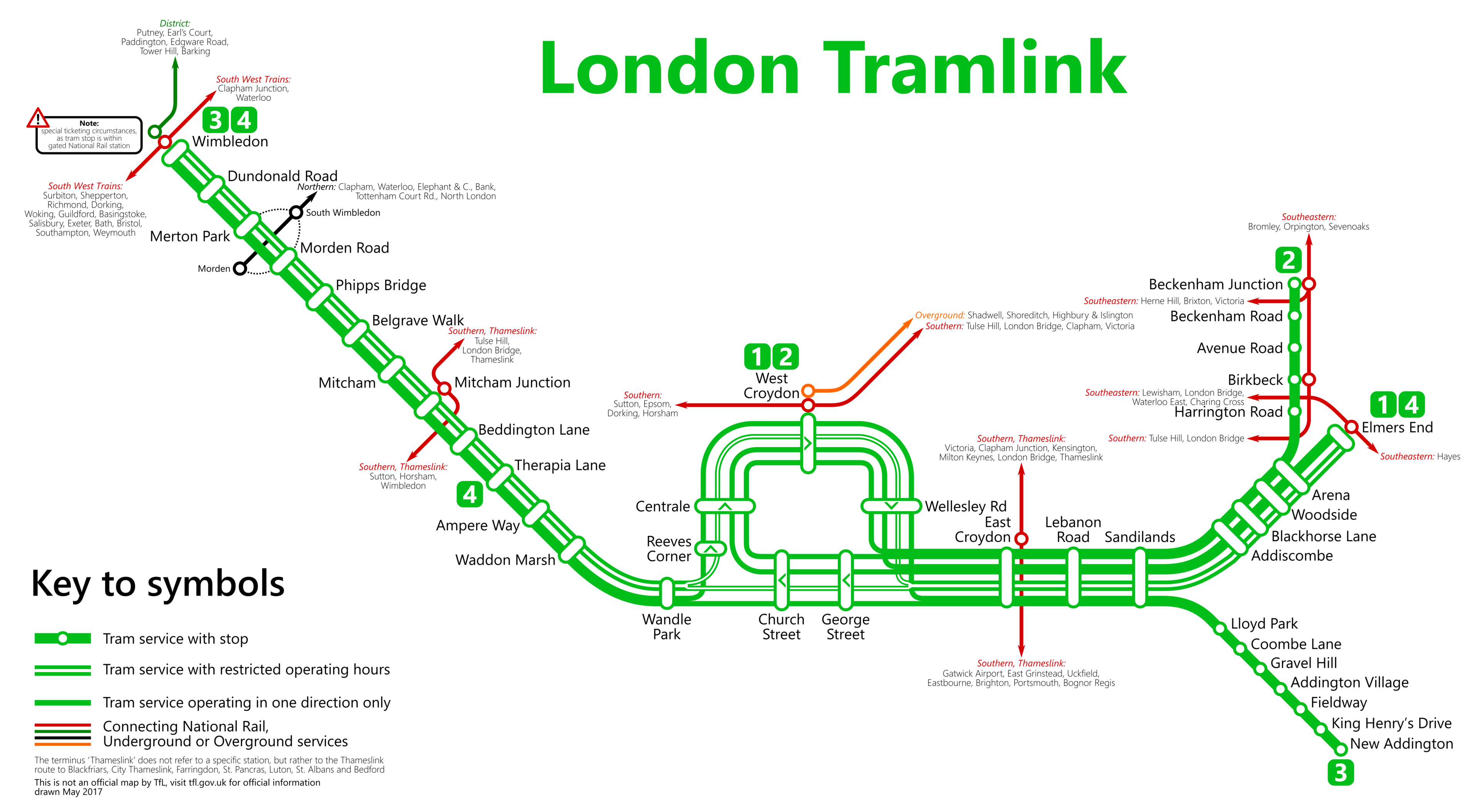
Bienvenido a los mapas en línea de las líneas de Tranvías de Londres. Consulta las estaciones en el mapa a continuación (Enero 2025).
 From Metrophil - Autor, CC BY-SA 4.0.
Si deseas explorar la totalidad de la red del Metro de Londres, te invitamos a ver el completo Mapa del Metro de Londres. Este recurso incluye una página donde todas las líneas están presentadas de manera ordenada (aunque separadas), o puedes optar por examinar las líneas individualmente simultáneamente.
Lista de estaciones y rutas del Tranvía de Londres
Ruta 1: Beckenham Junction - Wimbledon
| ESTACIONES | ZONA | INFO |
|---|---|---|
| Beckenham Junction | --- | |
| Beckenham Road | --- | |
| Avenue Road | --- | |
| Birkbeck | --- | |
| Harrington Road | --- | |
| Arena | --- | |
| Woodside | --- | |
| Blackhorse Lane | --- | |
| Addiscombe | --- | |
| Sandilands | --- | |
| Lebanon Road | --- | |
| East Croydon | --- | |
| George Street | --- | |
| Church Street | --- | |
| Wandle Park | --- | |
| Waddon Marsh | --- | |
| Ampere Way | --- | |
| Therapia Lane | --- | |
| Beddington Lane | --- | |
| Mitcham Junction | --- | |
| Mitcham | --- | |
| Belgrave Walk | --- | |
| Phipps Bridge | --- | |
| Morden Road | --- | |
| Merton Park | --- | |
| Dundonald Road | --- | |
| Wimbledon | --- |
Ruta 2: Elmers End - Wimbledon
| ESTACIONES | ZONA | INFO |
|---|---|---|
| Elmers End | --- | |
| Arena | --- | |
| Woodside | --- | |
| Blackhorse Lane | --- | |
| Addiscombe | --- | |
| Sandilands | --- | |
| Lebanon Road | --- | |
| East Croydon | --- | |
| George Street | --- | |
| Church Street | --- | |
| Wandle Park | --- | |
| Waddon Marsh | --- | |
| Ampere Way | --- | |
| Therapia Lane | --- | |
| Beddington Lane | --- | |
| Mitcham Junction | --- | |
| Mitcham | --- | |
| Belgrave Walk | --- | |
| Phipps Bridge | --- | |
| Morden Road | --- | |
| Merton Park | --- | |
| Dundonald Road | --- | |
| Wimbledon | --- |
Ruta 3: New Addington - Church Street
| ESTACIONES | ZONA | INFO |
|---|---|---|
| New Addington | --- | |
| King Henry's Drive | --- | |
| Fieldway | --- | |
| Addington Village | --- | |
| Gravel Hill | --- | |
| Coombe Lane | --- | |
| Lloyd Park | --- | |
| Sandilands | --- | |
| Lebanon Road | --- | |
| East Croydon | --- | |
| George Street | --- | |
| Church Street | --- |
Mapa del metro de Londres | Horarios | Tarifas | Todas las líneas de metro