Karte der Straßenbahnlinien
Aktualisiert: Januar 2025
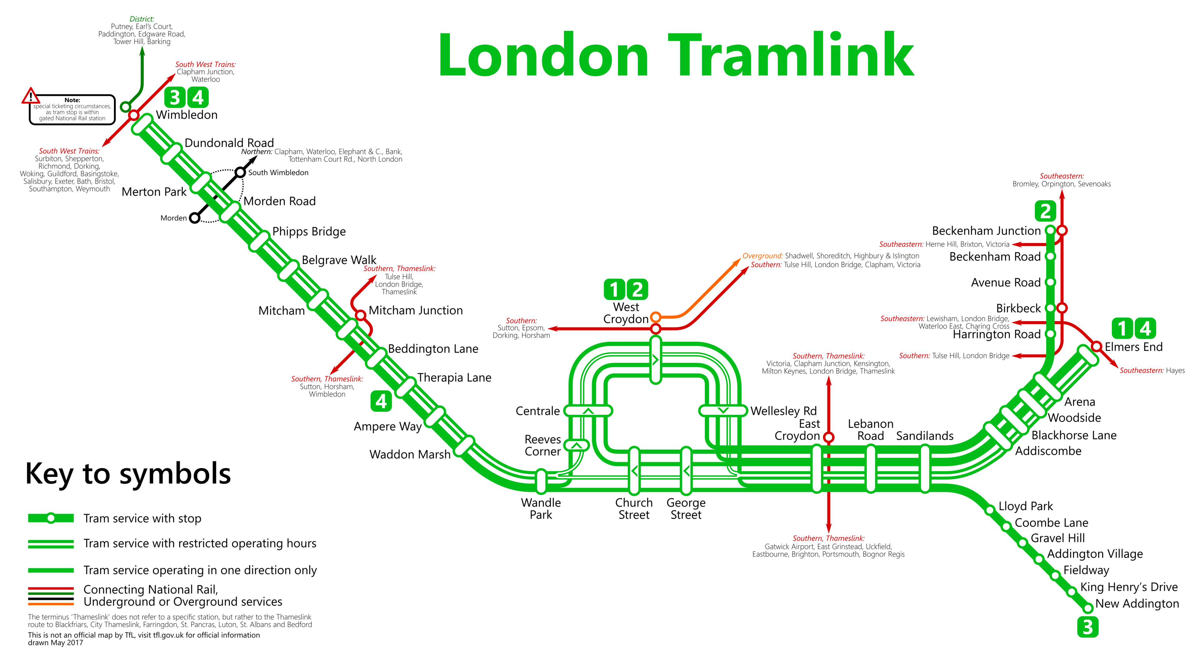
Willkommen bei den Online-Karten der Londoner Straßenbahnlinien. Sehen Sie die Stationen auf der untenstehenden Karte (Januar 2025).
→ Vergrößern ←
 Von Metrophil - Autor, CC BY-SA 4.0.
Sollten Sie das gesamte Netz der Londoner U-Bahn erkunden wollen, sind Sie eingeladen, die umfassende Londoner U-Bahn-Karte zu betrachten. Diese Ressource beinhaltet eine Seite, auf der alle Linien übersichtlich zusammengefasst (und dennoch deutlich getrennt) dargestellt sind, oder Sie können sich dafür entscheiden, einzelne Linien gleichzeitig zu untersuchen.
Liste der Stationen und Routen der Londoner Straßenbahn
Route 1: Beckenham Junction - Wimbledon
| STATIONEN | ZONE | INFO | Beckenham Junction | --- |
|---|---|---|
| Beckenham Road | --- | |
| Avenue Road | --- | |
| Birkbeck | --- | |
| Harrington Road | --- | |
| Arena | --- | |
| Woodside | --- | |
| Blackhorse Lane | --- | |
| Addiscombe | --- | |
| Sandilands | --- | |
| Lebanon Road | --- | |
| East Croydon | --- | |
| George Street | --- | |
| Church Street | --- | |
| Wandle Park | --- | |
| Waddon Marsh | --- | |
| Ampere Way | --- | |
| Therapia Lane | --- | |
| Beddington Lane | --- | |
| Mitcham Junction | --- | |
| Mitcham | --- | |
| Belgrave Walk | --- | |
| Phipps Bridge | --- | |
| Morden Road | --- | |
| Merton Park | --- | |
| Dundonald Road | --- | |
| Wimbledon | --- |
Route 2: Elmers End - Wimbledon
| STATIONEN | ZONE | INFO | Elmers End | --- |
|---|---|---|
| Arena | --- | |
| Woodside | --- | |
| Blackhorse Lane | --- | |
| Addiscombe | --- | |
| Sandilands | --- | |
| Lebanon Road | --- | |
| East Croydon | --- | |
| George Street | --- | |
| Church Street | --- | |
| Wandle Park | --- | |
| Waddon Marsh | --- | |
| Ampere Way | --- | |
| Therapia Lane | --- | |
| Beddington Lane | --- | |
| Mitcham Junction | --- | |
| Mitcham | --- | |
| Belgrave Walk | --- | |
| Phipps Bridge | --- | |
| Morden Road | --- | |
| Merton Park | --- | |
| Dundonald Road | --- | |
| Wimbledon | --- |
Route 3: New Addington - Church Street
| STATIONEN | ZONE | INFO | New Addington | --- |
|---|---|---|
| King Henry's Drive | --- | |
| Fieldway | --- | |
| Addington Village | --- | |
| Gravel Hill | --- | |
| Coombe Lane | --- | |
| Lloyd Park | --- | |
| Sandilands | --- | |
| Lebanon Road | --- | |
| East Croydon | --- | |
| George Street | --- | |
| Church Street | --- |
Londoner U-Bahn-Karte | Fahrplan | Tarife | Alle U-Bahn-Linien